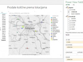
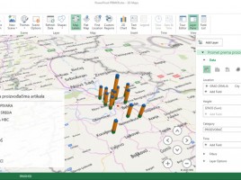
3D maps

3D Maps (PowerMaps) is tool for graphical representation of data in relation to geographical locations on a 3D model of the planet Earth. It is an Excel add-in that is of version 2016 became an integral part application. Based on location data from the Model Excel is connected with Bing maps and finds geographical coordinates on which to draw map charts for given reporting dimensions, such as turnover (sales) or price difference …

Maps in Power View reports

If Data model contains some universal geographic information (name of city, region, country, etc.) we can use them to create a chart within Power View. It enables creating maps based on Bing maps, after it automatically turns on the mechanism for searching and comparing geographical data from the model with the database of geographical locations. Maps are part of Power View reports ecosystem and they make a great supplement to the reporting panel.